-
It is a Tibetan name for ‘high grassland lake’
-
It is also called Pangong Lake.
-
It is a long narrow, deep, endorheic (landlocked) lake situated at a height of about 4,350 m.
-
It is 134 km long and extends from India to Tibetan Autonomous Region (TAR), China.
-
It is a brackish water lake in Himalayas.
-
It is an endorheic lake.
-
India holds just 1/3rd of the lake.
-
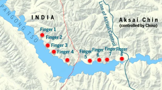
The lake has mountain spurs of the Chang Chenmo range jetting down referred to as fingers which are divided 8 parts.
-
The Chinese say that the Line of Actual Control(LAC) is at finger 4. But, India’s perceived LAC is at finger 8. This leads to frequent disputes in the area.
-
The North bank of the lake has much higher differences in perception of LAC than the South bank (South Bank of Pangong leads to Kailash range and to the Chushul sector).
-
In 2020, as part of the first phase of disengagement, India and China have agreed for complete disengagement on the North and South Banks of Pangong Lake.
-
Currently, the Indian Army has a permanent position near Finger 3, the Dhan Singh Thapa post, while the PLA has a base East of Finger 8.
-
Why in news? China is building a bridge across this lake.