-
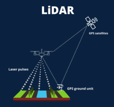
LiDAR (Light Detection and Ranging) is a remote sensing method that uses light in the form of a pulsed laser to measure ranges & variable distances.
-
These light pulses combined with other data recorded by the airborne system generate precise, three-dimensional information about the shape of the Earth and its surface characteristics.
-
LiDAR instrument principally consists of
-
Airplanes and helicopters are the most commonly used platforms for acquiring LiDAR data over broad areas.
-
Applications: LiDAR is used for agriculture, hydrology and water management systems, geology-related applications and also in archaeology.