Basics:
-
India shares total boundary of around 3,488 km with China (second largest after Bangladesh).
-
The Sino-Indian border is generally divided into three sectors namely: Western sector, Middle sector, and Eastern sector.
-
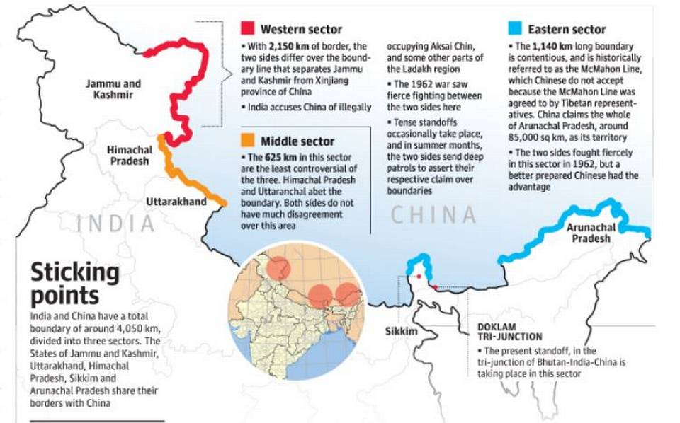
5 states viz. Jammu & Kashmir, Himachal Pradesh, Uttarakhand, Sikkim and Arunachal Pradesh share border with China.
Western Sector:
-
In the western sector, India shares about 2152 km long border with China.
-
It is between Jammu and Kashmir and Xinjiang Province of China.
-
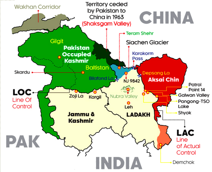
In this sector, there is territorial dispute over Aksai Chin.
-
Both countries went to war in 1962 over disputed territory of Aksai Chin.
-
India claims it as part of Kashmir, while China claims it is part of Xinjiang.
-
The dispute over Aksai Chin can be traced back to the failure of the British Empire to clearly demarcate a legal border between China and its Indian colony.
-
During the time of British rule in India, two borders between India and China were proposed Johnson’s Line and McDonald Line.
-
The Johnson’s line (proposed in 1865) shows Aksai Chin in Jammu and Kashmir i.e. under India’s control whereas McDonald Line (proposed in 1893) places it under China’s control.
-
India considers Johnson Line as correct, rightful national border with China, while on the other hand, China considers the McDonald Line as the correct border with India.
-
At present, Line of Actual Control (LAC) is the line separating Indian areas of Jammu and Kashmir from Aksai Chin. It is concurrent with the Chinese Aksai Chin claim line.
Middle Sector
-
In this sector, India shares about 625 km long boundary with China which runs along the watershed from Ladakh to Nepal.
-
The states of Himachal Pradesh and Uttarakhand touch this border with Tibet (China) in this sector. Both sides do not have much disagreement over border in this area.
Eastern Sector
-
In this sector, India shares 1,140 km long boundary with China.
-
It runs from the eastern limit of Bhutan to a point near the Talu Pass at the trijunction of Tibet, India and Myanmar.
-
This boundary line is called McMahon Line.
-
The boundary was established along the Himalayan crest of the northern watershed of the Brahmaputra, except where the Kemang, Subansiri, Dihang and Lohit rivers break through that watershed.
-
China considers the McMahon Line illegal and unacceptable claiming that Tibetans representatives who had sign the 1914 Convention held in Shimla which delineated the Mc Mahon line on the map were not having rights to do so.
Controversy around Line of Actual Control (LAC):
-
The LAC is the demarcation that separates Indian-controlled territory from Chinese-controlled territory.
-
India considers the LAC to be 3,488 km long, while the Chinese consider it to be only around 2,000 km.
-
The alignment of the LAC in the eastern sector is along the 1914 McMahon Line, and there are minor disputes about the positions.
-
India rejected the concept of LAC in both 1959 and 1962.
-
After the 1962 War, the Chinese claimed they had withdrawn to 20 km behind the LAC in November 1959.
-
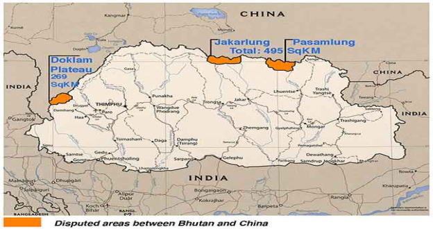
During the Doklam crisis in 2017, China urged India to abide by the “1959 LAC”.
-
India objected that the Chinese line was a disconnected series of points on a map that could be joined up in many ways.
-
India’s claim line is the line seen in the official boundary marked on the maps as released by the Survey of India, including both Aksai Chin and Gilgit-Baltistan.
-
In China’s case, it considers mostly the entire Arunachal Pradesh as South Tibet.
Bestest note